Socio-environmental Spatial Information, Cloud Computing, and
Effective Governance for a Sustainable Latin America
Want to participate?
Tell us about your interests using the button below
What is Digital Earth Americas?
Digital Earth Americas aims to improve access to, processing of, and use of interoperable satellite data and will complement and connect to, rather than duplicate, existing national efforts. It will promote collaboration across sectors and will leverage international experiences and solutions, adapted to ensure local relevance.
Background
Earth Observation has demonstrated an ability to support local, national and regional (e.g., Africa Regional Data Cube) decision making and the Sustainable Development Goals (SDGs) through a number of successful country-level Open Data Cube (ODC) initiatives around the world. The Americas are ready for a similar path. With the support and involvement of key stakeholders, it is possible to bring together users in the Americas region to create an open, sovereign and operational in-country expertise in data analysis, use and management for evidence-based policy, decisions and action.
Key Goals of Digital Earth Americas
Goal #1: Understanding user needs
Concepts such as Digital Earth Americas need to be focused on real-world user needs and not be driven by specific technologies or a perspective that if it works in one location, it must also work elsewhere. It is therefore very difficult to step towards a large-scale solution without having a broad understanding of user needs and challenges across the region. The diversity in the region creates a significant challenge regarding the sort of information that different users need from data as well as the way it needs to be delivered.
Goal #2: Delivering value to users
It is essential that the core objective of Digital Earth Americas is to deliver value to users. A critical component to having this value realised is to help users across the region to be able to use the tools, data and systems that already exist or might be built under Digital Earth Americas. While data and technology are available from many sources around the world, in addition to the need for capacity building, there are still significant challenges with data access, data preparation and delivery.
Progress
The concept of Digital Earth Americas initially evolved through a various workshops in 2020 and 2021. Recent conversations are being coordinated by Adolfo Ibáñez University, CSIRO and Wilp Capacity Development. This team is currently development a new value proposition and proposal for Digital Earth Americas to continue advancing towards a first phase.
On August 2020, INEGI, NASA-CEOS and UN-ECLAC, kick-started Digital Earth Americas with an online workshop. Later, as part of CSIRO-Chile and INEGI’s collaborative projects, three more workshops have been provided to the community of EO users in the region (UN-ECLAC, AmeriGEO and UN-GGIM: Americas):
- The first workshop, titled: “Exploring the value and challenges of using EO data” gathered participants from 15 different countries (Argentina, Australia, Chile, Colombia, Costa Rica, Ecuador, El Salvador, Guatemala, Jamaica, Mexico, Paraguay, Peru, Switzerland, United States, Uruguay).
- The second workshop, titled: “Different tools for different needs” achieved a higher participation, reaching 21 countries (Argentina, Bolivia, Brazil, Chile, Colombia, Costa Rica, Dominican Republic, Ecuador, El Salvador, Guatemala, Honduras, Mexico, Nicaragua, Panama, Paraguay, Peru, Suriname, Switzerland, United States, Uruguay, Venezuela).
- A third workshop presented deep-dive studies for specific country needs (Jamaica and Costa Rica); allowing to also prove the capacity and commitment from the technical team to adapt to different cases and the flexibility of the Data Cube-based solutions.
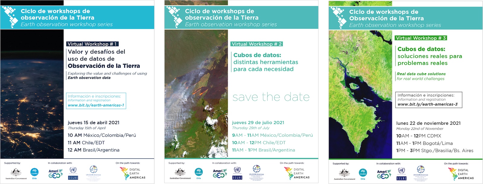
This workshop-series was aimed at members of various organizations in countries throughout the Americas. Several experts presented their experiences and participated in an interactive discussion regarding different types of data cube solutions ranging from simple but more accessible options through to complex cloud-based platforms. There were also discussions on the benefits and challenges of different platforms as well as the kind of expertise that is required to use, develop, and implement different systems.